Karnataka State Remote Sensing Applications Centre
Department of Personnel and Administrative Reforms (e-Governance), Government of Karnataka
Department of Personnel and Administrative Reforms (e-Governance), Government of Karnataka
Department of Personnel and Administrative Reforms (e-Governance), Government of Karnataka
The application is developed for Agriculture department to provide the GIS based Mobile application of hissa wise soil sample collected in the field.
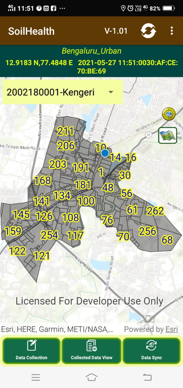
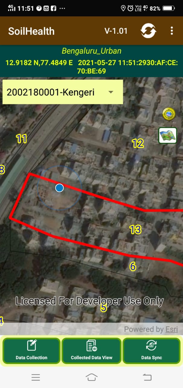
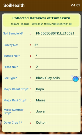
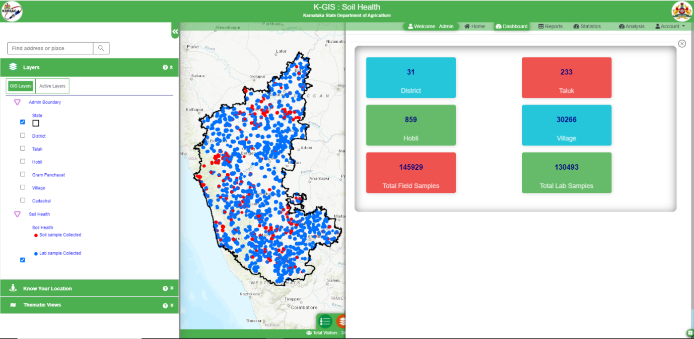
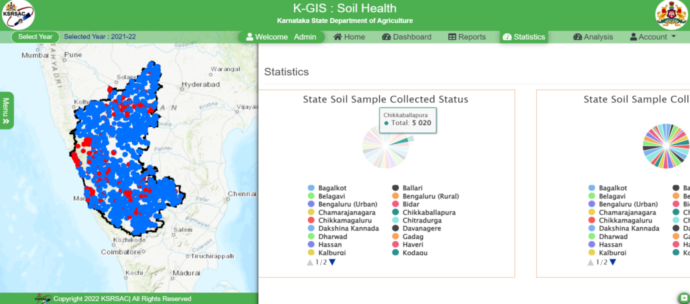
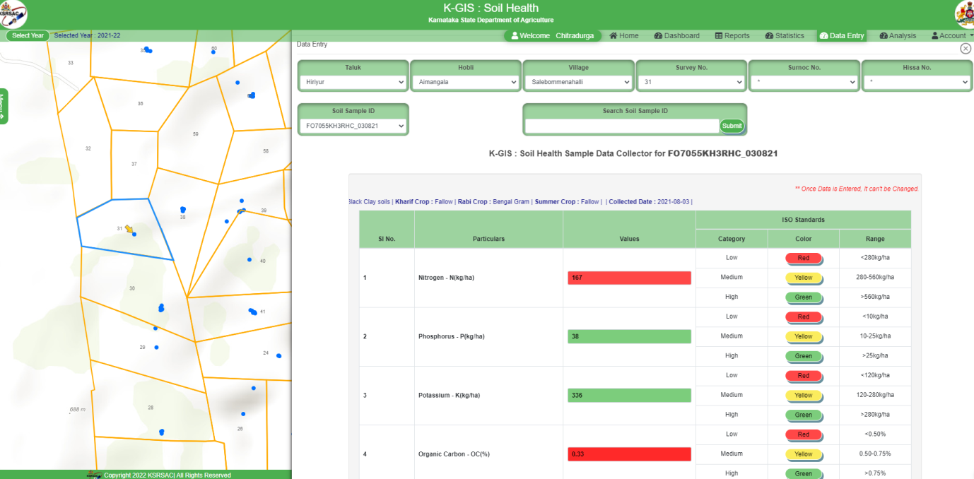
The application is developed for Agriculture department to provide the GIS based web application for monitoring of hissa wise soil sample collected in the field. It also enables department to enter the physicochemical parameters to the respective sample collected points, after the laboratory analysis. Used specific map visualization customization will be provided based on the histogram of the data (smart mapping).
Ongoing
The vision of the project is to create one single verified source of crop data in the state that can be utilised by multiple departments and other agents in the eco-system such as Banks, Insurance agencies etc., and this will ensure consistency in records across all databases like Parihara, RTC, Samrakhshane, etc.,
The goal is to ensure that all the systems have access to accurate & up-to-date Farmer & crop data in a timely manner. KSRSAC provides the entire state digitized revenue village maps for crop survey mobile application.
Ongoing
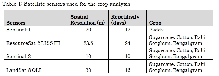
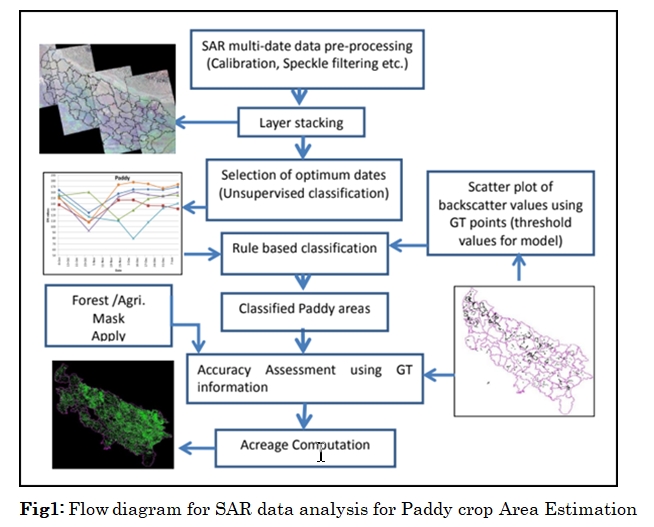
Forecasting Agricultural output using Space Agro-meteorological and Land-based observation (FASAL) project of Department of Agriculture & Co-operation and Farmers Welfare, GoI. Optical and microwave remote sensing data is used for crop acreage estimation, crop condition assessment and production forecasting for the major crops of the state in collaboration with MNCFC during 2021-2022.
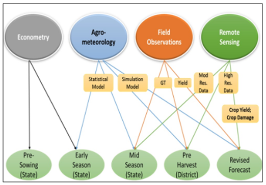
District level yield has been estimated using weather-based regression and remote sensing index (Vegetation Crop Index) based models.
Ongoing
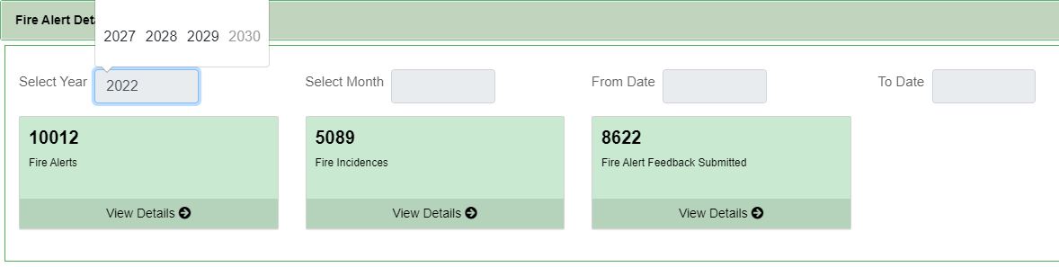
Forest fires are a major setback for forest managers, the public and the general ecology of the area. Each year in Karnataka hundreds of hectares of forests are destroyed by forest fire particularly from January to May. Forests in Karnataka represent large diversity in terrain and agro-climatic conditions. Therefore the use of low-flying, cost-effective aerial platforms for acquiring visuals of the forests at very high resolutions will be effective in monitoring. This data and its interpretations shall provide documented records of various activities (lawful and unlawful) taking place in the forest land at a given time. Regular surveillance shall also help in quantifying damages due to fires, floods and other natural and manmade calamities.
In keeping with the latest trends, the Karnataka forest department decided to create a Forest Fire monitoring and analysis cell (Forest Fire Cell) at KSRSAC to support the department in its efforts to reduce, monitor and analyze fire incidents. Based on the results and the achievement made from the project, KFD felt the need to extend this project for monitoring the forest fires every year. In this context, the project was continued for the year 2021-22.
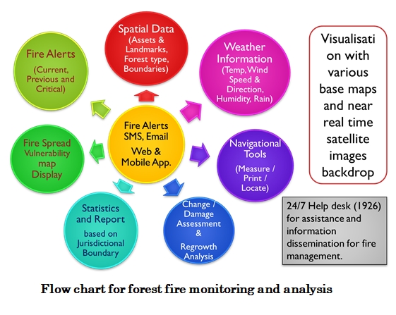
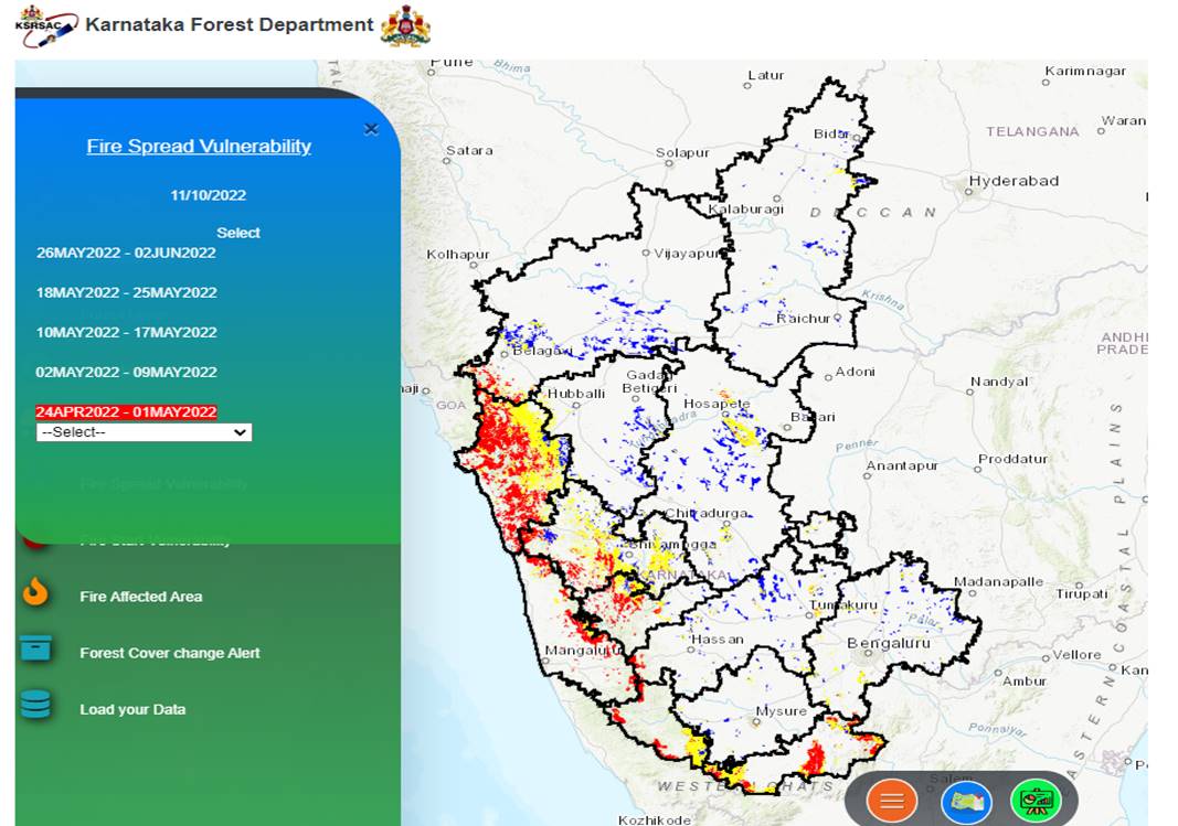
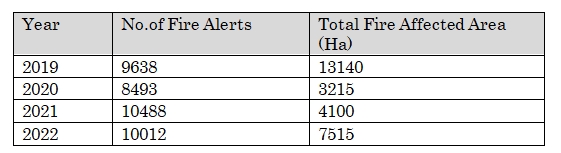
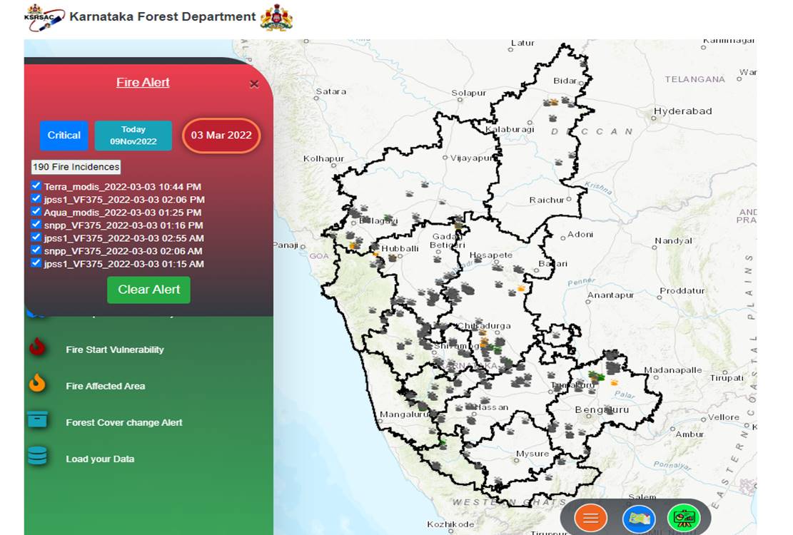
The above activities and technologies have resulted in a significant impact on controlling forest fires. Big fire incidents have not occurred after the establishment of this Cell.
Ongoing
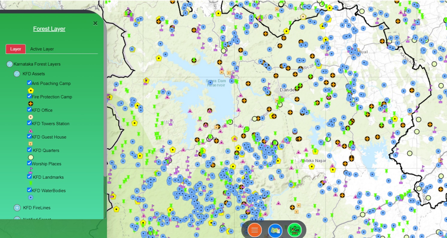
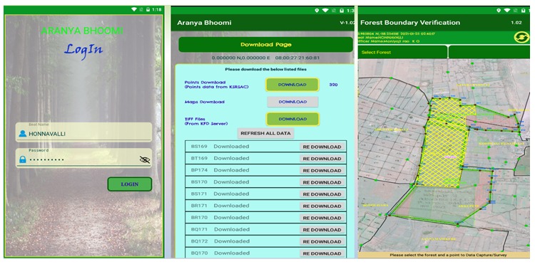
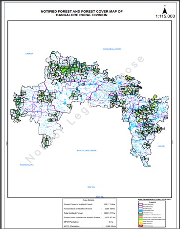
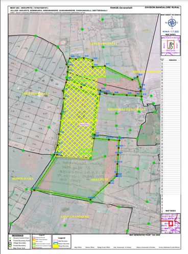
The fringe areas of forests in Karnataka are often influenced and encroached upon by human activities. To safeguard the forests from these negative influences effectively and also to manage forest resources it is proposed to develop a GIS-based digital cadastral database of notified forest lands. In this context, the Karnataka Forest Department initiated the project for the preparation of a geospatial database of notified forests of Karnataka using GCPs based on the survey number-wise forest notification and integrating with revenue village maps. This will help in developing land resource information systems for forest areas. This project is being executed by KSRSAC in collaboration with Karnataka Forest Department and RRSC – S.
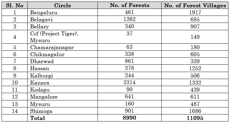
ObjectivesThe state has been divided into 13 Circles, 52 Forest divisions and 26 wildlife sanctuaries for administrative purposes and the forest areas come in approximately 11095 villages. The circle-wise list of the village is given below:
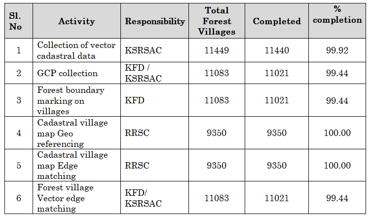
As an interim work to create a digital database of forest lands of Karnataka state using the available seamless cadastral data following work elements were taken up:
The process of the identification and demarcation of forest boundaries based on the survey number-wise notification of forest lands is explained below:
GSFIS web and mobile applications were developed with the following functionalities to facilitate smooth data transactions:
Ongoing
This work has been entrusted to KSRSAC by KFD for providing the remote sensing data-based evidence to support the Ministry of Tribal Welfare, GoI. The Ministry of Tribal Welfare, GoI brought out The Schedule Tribes and Other Traditional Forest Dwellers (Recognition of Forest Rights) Act-2006 and Rules in 2008 and it is notified for implementation from 1st January 2008. The act provides individual rights to forest land which is cultivated by forest-dwelling Scheduled Tribes and other Traditional Forest dwellers who have occupied the forest land on or before 13th December 2005 and continue to be under their occupation.
Objective
Ongoing
Karnataka Forest Department has engaged Karnataka State Remote Sensing Applications Centre, Bengaluru to analyze forest types and densities using satellite images of the year 2000. Even though the Forest Survey of India (FSI), Dehradun analyses the forest cover every two years using LISS III imagery of 23.5 resolution, their analysis is on a rather macro level. Based on the above, KFD envisages the use of high-resolution satellite image data to obtain more information about Karnataka's forest area. Therefore, the 50 cm resolution satellite data are used to perform detailed forest coverage mapping to accomplish the following objectives.
Objectives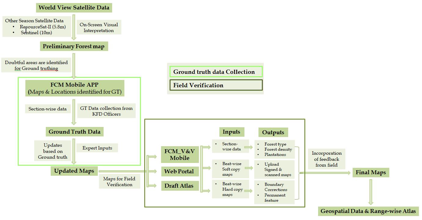 Workflow for creating the forest type & forest canopy density maps
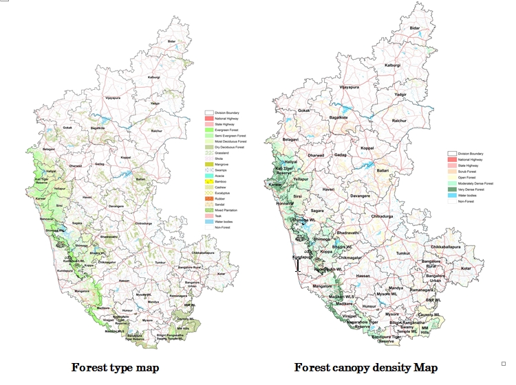
Ongoing
The major scope of the project is to generate a unified Geo spatial database for the unclassified forests at cadastral level and to provide training to KFD officers on modern GPS surveying technologies.
Ongoing
The Honourable Supreme Court’s Ore assessment committee (OAC) tasked KSRSAC with preparing pre-level surface plans and assessing the volume of extracted material from 62 “B” category mines in Karnataka.
Scope of work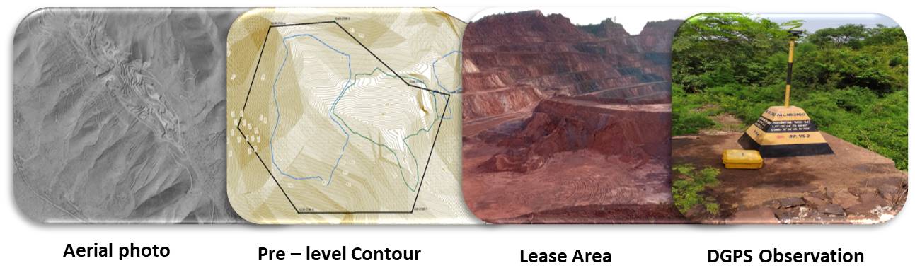
Ongoing
Objectives
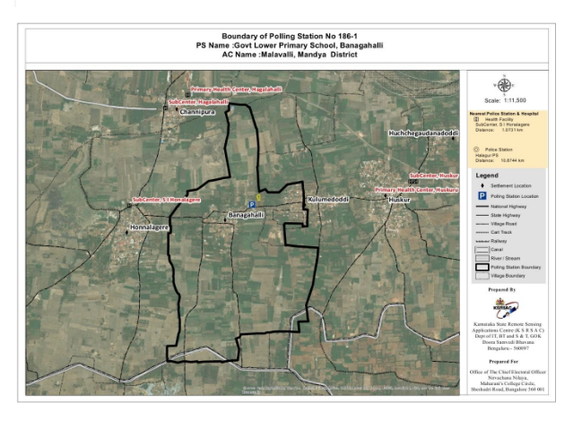
To geo-tag the 56696 polling station in the state and delineation of polling station limits covering 224 assembly constituencies.
The tasks include:
a) Identification and mapping of Polling station location
b) Delineation of Polling station limits.
c) Creation of state seamless database of the Polling station and jurisdiction boundary.
Ongoing
In view of Karnataka Legislative Assembly Elections of 2023, The Chief Electoral Office envisioned the need, to create a GIS map of all the polling stations (booths) and their respective geographic boundaries for the state. Towards this endeavor, Joint CEO approached KSRSAC to map all the Polling Stations and their electoral boundaries, along with various attribute information of polling stations.They include infrastructure facilities for citizens, location information, area information, voters information, candidate information and more.
Ongoing
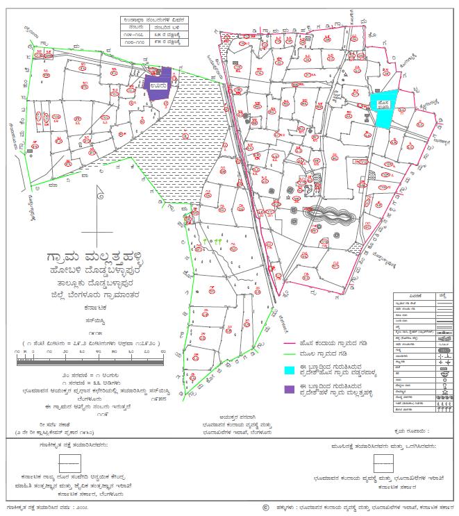
KSRSAC geo-referenced all 30854 village maps and created a seamless mosaic on the CartoSAT (2.5m spatial resolution) satellite image, which was later spatially geo-referenced on 50 cm satellite data and mosaic generated using Karnataka GIS (K-GIS). This geo-referenced seamless village map, known as a cadastral map, is used by various departments of the GoK, including Agriculture, Horticulture, Industries, Water Resources, Forest, Watershed Development, and so on, for the implementation and monitoring of their respective schemes, survey number wise. These cadastral maps lack subdivided boundaries, so it is not possible to link the Bhoomi database to actual land parcels owned by individual farmers. Since spatial data on individual land ownership are not available, identifying the actual beneficiary under various schemes during field data collection and validation is difficult. Therefore the Revenue Department GoK felt the need to incorporate HISSA boundaries in the existing cadastral maps and thus entrusted the work to KSRSAC. Currently, around 200 engineers are working on Hissa digitization activities, image verification, geo-referencing, and the finalisation of a seamless cadastral map.
Objectives
Ongoing
The REWARD Program will be implemented for five years from 2021-22 to 2026-27 in twenty-one districts of Karnataka State viz., Bidar, Kalburagi, Yadgir, Koppal, Kolar, Gadag, Davanagere, Dharwad, Chamarajnagar, Raichur, Chimmakamagalur, Vijayanagara, Tumakuru, Vijayapura, Haveri, Bagalkot, Hassan, Shivamogga, Chitradurga, Chikkaballapura and Belagavi in selected watersheds covering an area of about 20 lakh ha. LRI study is proposed in the entire 20 lakh has to be carried out by LRI partners of WDD.
Objectives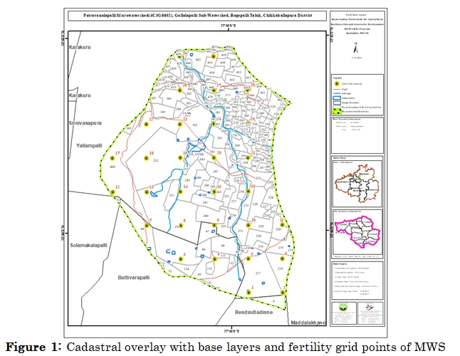
Ongoing
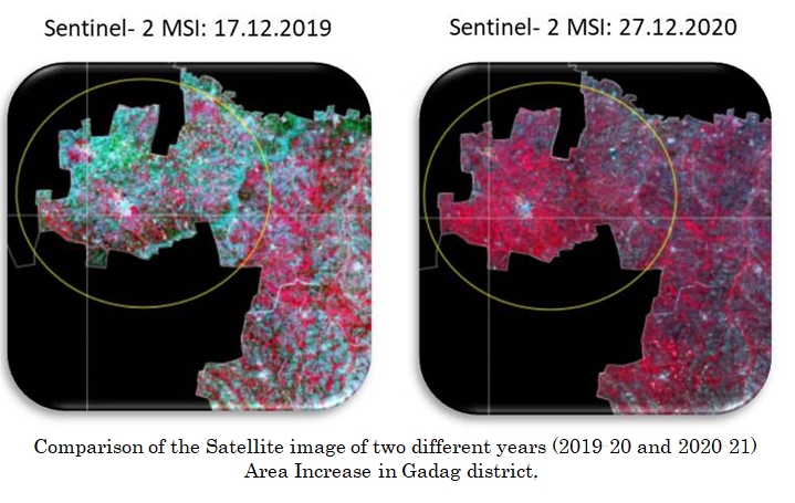
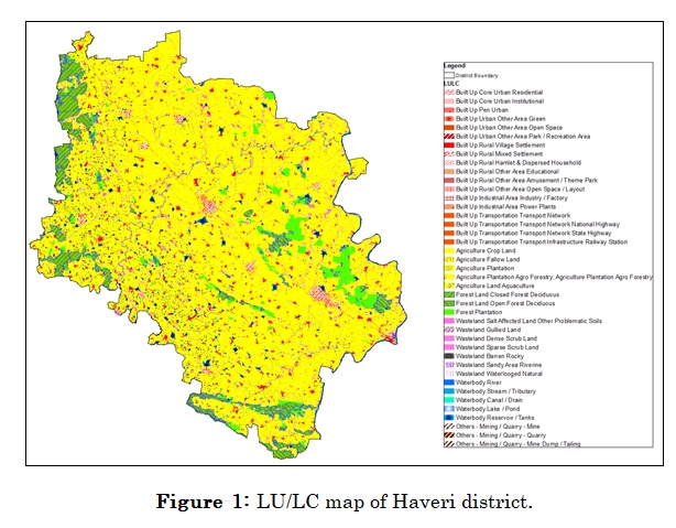
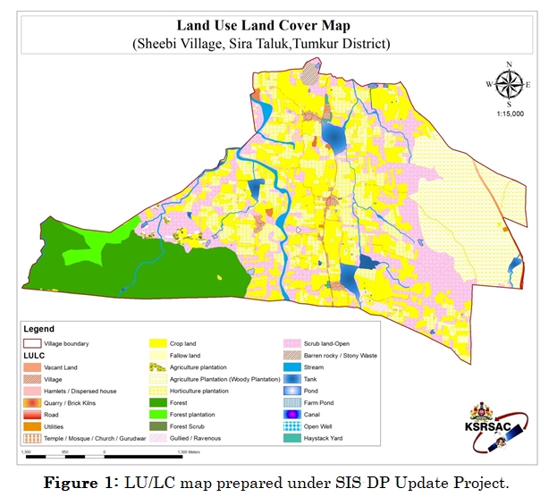
NRSC developed the Space-based Information Support for Decentralized Planning Update (SIS-DPU) project to update the base layers and LU/LC with 2017-18 and the earliest equivalent or high-resolution satellite data. The data of the SIS-DP (Phase-I) programme was previously generated using 2010-2011 satellite data and it was conceptualised and implemented by NRSC in collaboration with the country's State Remote Sensing Applications Centers. This programme aims to provide geospatial information to the people at the grassroots level (Gramapanchayat level) to assist them in scientifically informed planning, implementation, and monitoring of various developmental schemes. The current SIS-DP Update Program aims to generate updated geospatial thematic layers mainly for four themes (Land use land cover, Infrastructure, drainage network, and Settlement) for the state. The specific goal is to emphasize standardization and harmonization of land cover classification systems by providing details up to level IV classification consisting of 89 classes. The level III, level II and Level I classifications will consist of 41, 27 and 7 classes respectively. The LULC map of the Haveri district thus created under the programme is provided in Figure 1 below:
Ongoing
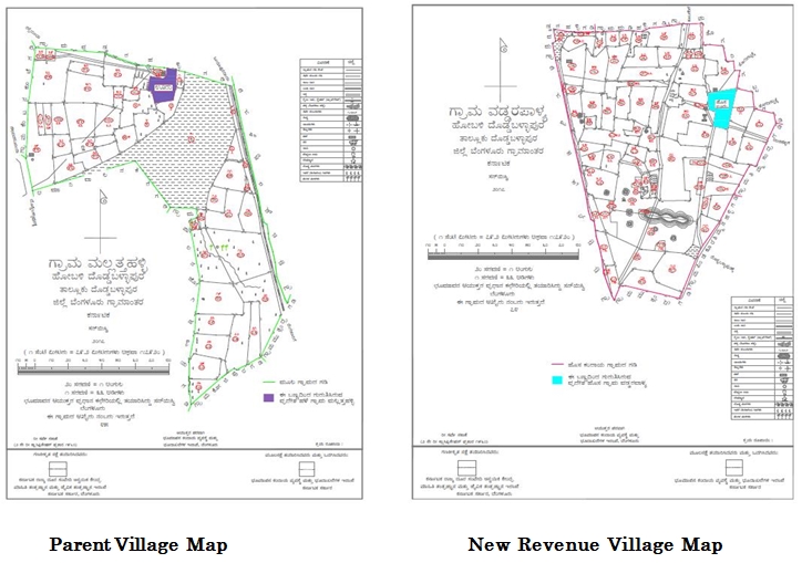
The revenue villages in Karnataka contain areas like Thanda, Hatti, Koppalu, etc. These are habitat areas in addition to the village's main settlement / gramatana, where people have lived for a long time. To award ownership rights to residents of these areas, the government established a New Revenue Cell within the Revenue Department. This Cell's mission is to establish a new revenue village, a child village separated from a single or set of main or parent villages. Mark the habitat regions as gramatana for the newly constituted revenue village.
Since KSRSAC is already working on digitizing the revenue department's parent Revenue Survey Maps / Village Maps, this New Revenue Village data production project was entrusted to the Center. Based on the information provided by the Revenue Department, KSRSAC will generate these maps and share hard copies of the maps with the department. The project is funded by the Revenue Department. Following the government's formal notification and certification as new villages, these villages will be incorporated for use by other GoK departments and citizens.
To date, the digitization and separation of 1691 new revenue villages from the parent village have been completed for issuing a final notification. In addition, 1717 NRV villages were delineated from the parent village and a map is provided for preliminary notification. Further, 1865 NRV village re-work is carried out and corresponding map print is provided to the dept. PDF maps of the NRV maps generated are shared with the dept. for documentation and publishing purposes.
Ongoing
After completing its three-year mission mode period (April 2016 to March 2019), the K-GIS Program resumed operations in April 2019 under DPAR (e-Governance).
The various geospatial activities undertaken by K-GIS in the year 2021-22 are based on the requirements shared by the departments of the Government of Karnataka (GoK). For the operational activities of monitoring, planning, and decision support, the activities include GIS data organisation, spatial data and database management, web and mobile application development, and so on. Aside from that, KSRSAC user department projects involving GIS web/mobile application development components were also undertaken under K-GIS. The K-GIS team also developed applications for KSRSAC in-house activities such as project monitoring and resource analysis.
From April 2021 to March 2022, the following activities were carried out as part of the K-GIS Program.
The following are the highlights of major activities carried out during reporting period.
Ongoing